Soils
According to the Language Royal Academy, Geology is the "science that deals with inner and outer form of the terrestre globe, the nature of the materials and the changes or alterations that they have experienced since the origin, and the placement that they have in present situation."
Based on lithological and hydrological characteristics, we can distinguish the following geological formations in Spain.
- Zones formed by loose or semiconsolidated materials, such as gravel, sand and silt that cover the valley bottoms of major rivers like Ebro and Guadalquivir, and deposits of a similar nature that span the Duero and Tajo plateau, and coastal areas and deltas of the Ebro and Llobregat or Castellón and Valencia.
- Zones with carbonated rocks, generally limestone, situated in the Eastern and southern sector of the peninsula and the Balearic Islands.
- In the western sector of the peninsula appear igneous rocks (slates and similar), materials classified as waterproof materials or with very low permeability
- En el sector occidental de la península aparecen en su gran mayoría terrenos con rocas ígneas (granitos y rocas afines) y metamórficas (pizarras y similares), materiales catalogados genéricamente como impermeables o de muy baja permeabilidad.
- In the Canary Islands the rocks are of volcanic nature. Inside of the peninsula appear little volcanic aquifers in Olot and Campo de Calatrava.


Figure 1. Geological map of Spain. Source: Sistema Integrado de Información del Agua. SIA
OROGRAPHY
Orography is the science that studies the relief of the earth. Affects to the characteristics of the hydrographic river basins and to the aquatic ecosystems; by the shape and altitude, the climate, the geomorphologicaland soil processes, and the water action are conditioned.


Figure 2.Geography ofSpain.Sistema Integrado de Información del Agua. SIA
LITHOLOGY
Is the part of geology that studies the nature and composition of the Earth's crust.
The lithology influences in the existence of aquifers and in the physicochemical water characteristics.


Figure 3.Lithologic map of Spain. Sistema Integrado de Información del Agua. SIA
EDAPHOLOGY
Edaphology is the science that studies the formation, evolution, and the mineralogical characteristics of soil and the distribution.
The main characteristic of the Spanish soils is the biodiversity.
Furthermore, the soil is the fine layer of fertile matter that cover the Earth surface. The soil is formed by mineral particles, organic matter, water, air and organisms. The formation is a slow process, so this resource can be considered as nonrenewable.
The water exerts important actions in the soil formation (physical and chemical weathering of substances) and from the point of view of fertility.
The thick of the soil in which grows the roots of plants, like structure located in the lithosphere and the biosphere, is the result of the climate effects on the surface of ground under the influence of the orography and the organisms.
The soil can suffer degradation process, as erosion, decrease of organic matter, pollution, salinization…that can be more rapid by the human activities. En arid or subarid climatic conditions, this problem will cause desertification.
The role of soil in the hydrologic cycle is basic to act a distributor of rainfall between runoff and and infiltration.
According to the Soil Taxonomy classification, established by the Soil Survey Staff of USA (Department of Agriculture of the United States. USDA), of the twelve that it establishes, in Spain we found reference to ten of them. By this reason, some geographers consider to the national territory like "little continent". Those that have major representation are:


Figure 4. Map of Soil Types


Figure 5. Map of Soil Types (suborders)

Table 1. Characteristics of the Soil Types according to the USDA classification
Considering the degree of soils evolution, in Spain, are represented from the youngest (entisoles) and little developed (inceptisoles), until soils in the last stages of evolution (ultisoles); in terms of texture, there are Entisols and Vertisols. Respect to the reaction of the soil (pH), there are mollisoles, alfisoles and spodosoles. In addition, there are gypsiorthids and salorthis, pertaining to the order of aridisoles; In the Canary Islands there is andisoles.
Based on the thermal regime, we can observe, from the cryic, in wich the average yearly temperature of the soil at 50 cm is between 0 and 8 º C, until the termic, in which the temperature is between 15 and 22 º C.
In relation to soil moisture conditions, there are Histosols and Aridisols with hydric deficit.
Distribution ofthese soilsin Spain.
- Inceptisols: These are soils with a greater presence in Spain, in the peninsula and in the insular area. These soils occupy a 60% of the territory and develop in them a productive agriculture. In the zones with inclination, the scarcity of vegetation cause erosion problems.
- Entisols: Cover approximately 20% of the territory preferently in high levels (recreational or forestal use), in the Mediterranean coastal where a productive agriculture is developed with frequent of irrigation and in river valleys, where traditional irrigation systems have been developed . Appear in Valencia and the Segura valley.
- Ardisols: Cover 9.5% of the territory, in areas where the evapotranspiration exceeds the perspiration the most part of the year. This factor limits the agricultural production. This soils appear in Almería, Albacete and in the Ebro basin.
- Histosols: Appear in depressed areas such as Ebro delta and in the stuary of Galicia, occupying 0.04% of the territory.
- Molisols: We found them in Asturias, Cantabria and Basque Country, associated normally to other soils. They suppose a 0.21% of the territory.
- Vertisoles: Approximately a 2% of the territory are occupied by this type of grounds. They are located in Andalucia.
- Ultisoles: Occupy 0.25% of the territory. Distinguished by their poverty and low fertility.
- Espodosols: Constitute 0.23% of the territory. These soils appear in high and cold regions of Galicia and Cantabria.
The following map represents the types of soils in Spain, according to the FAO classification


Figure 6. Main types of soils according to the FAO. Sistema Integrado de Información del Agua. SIA
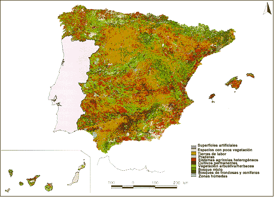
Spain has a total area of 50,645,719 ha (according to Corine Land Cover Project 2000). Almost 97.5% of the territory to the peninsular area, and the remaining 2.5% are constituted by sets Balearic and Canary island, and the cities of Ceuta and Melilla.
According to the Observatory of Sustainability in Spain, the land cover in Spain reflects a predominantly rural landscape.
- Agricultural lands occupy 50% of the surface:
 Arable lands, permanent crops and annual crops associated with permanent crops: 31.5%
 Arable lands:cereal crops, legumes, root crops and fallow land. Guadalquivir and Ebro depressions.
- Permanent cultures: fruit trees, olive trees and vineyards. The peninsular south and Mediterranean coast.
- Associated annual cultures to permanent cultures: heterogenous agricultural systems. Annual and permanent cultures coexist. Distributed by all the territory.
![]()


Figure 7. Land usemap
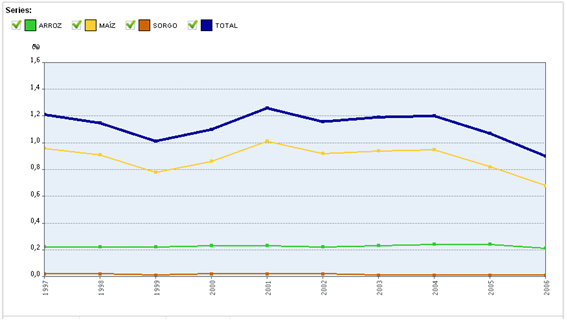
The following graphs and tables represent the Spanish area occupied by irrigated crops, rainfed and fallow in the period of time between 1997 and 2006 and in the different regions as well as the area of land occupied by these crops which more water needs (rice, maize and sorghum)


Figure 1. Area of Crop (thousand ha) for crops irrigated, rainfed and fallow. Source: Sistema Integrado de Información del Agua. SIA


Table 2. Area of Crops (irrigated, dry land and fallow) by region. Source: Sistema Integrado de Información del Agua. SIA


Graph 2. Surface in thousands of has occupied by the cultures with greater hydric needs: Sistema Integrado de Información del Agua. SIA

Table 3. Surface of intensive cultures by Independent Communities. Source: Sistema Integrado de Información del Agua. SIA
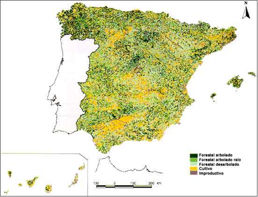
- Forest areas with natural vegetation and open spaces occupy 47.1% of the surface.
- Wooded: 26,8%
- No Wooded: 17,4 %
- Sspaces with little or without vegetation: 2,36%
- The artificial surfaces are 2.1% of the total
- The humid zones and water surfaces suppose 0.9% of the total.


Figure 8. Map of Forest Uses
OTHER INFORMATION AND DOCUMENTS OF INTERESTS
- Water System Indicators
- Digital Book of the Water
- Geographic Viewfinder
- CKeys to soil taxonomy
- Environmental Profile of Spain 2008. Report based on indicators (Soil)
READ MORE


Table 4. Soil data by regions


